
Geography: Grade 12 12 Sections44 Lessons365 Days
1.4. External (Exogenic) Forces
Geography – Grade 12 (Ethiopian Curriculum)
Lesson Competencies
At the end of the lesson, you will be able to:
Distinguish the mechanisms of various external geological processes, including different types of weathering (physical, chemical, biological), erosion (by water, wind, ice, and gravity), and deposition, providing specific examples of each.
Assess how different external forces interact to create and modify Earth’s surface features, such as valleys, deltas, sand dunes, and coastlines, and predict the long-term effects of these processes on specific landscapes.
Identify direct and indirect evidence of weathering, erosion, and deposition in their local environment or through case studies, applying their understanding to explain observed geological features and potential associated risks (e.g., landslides, soil erosion).
Key Terms
Weathering
The in-situ breakdown of rocks and minerals at or near Earth’s surface through physical, chemical, or biological processes.
Erosion
The removal and transportation of weathered material by natural agents such as water, wind, ice, and gravity.
Deposition
The process by which sediment and rock particles settle out of the transporting medium (water, wind, ice) and accumulate in a new location.
Mass Wasting
The downslope movement of rock, regolith, and soil under the direct influence of gravity without a transporting medium.
Exogenic Forces
External geological processes powered primarily by the Sun and gravity that wear down and reshape Earth’s surface features.
Runoff
Water flowing over the land surface, which is a major agent of erosion that creates features like rills, gullies, and valleys.
Delta
A triangular or fan-shaped landform created by deposition of sediment at the mouth of a river where it enters a larger body of water.
Sand Dunes
Hills or ridges of sand formed by wind action, typically found in deserts and along coastlines.
Video Lesson
Core Lesson
Introduction
Dear learners,
Imagine standing at the edge of the Grand Canyon, looking down at layers of rock carved by millions of years of water flow. Or picture the vast Sahara Desert, where wind has sculpted magnificent sand dunes that stretch as far as the eye can see. These breathtaking landscapes weren’t created overnight—they’re the result of powerful external forces that have been shaping our planet’s surface for billions of years!
Today, we embark on an exciting journey to explore External (Exogenic) Forces—the natural processes that continuously wear down mountains, carve valleys, build deltas, and reshape coastlines. Unlike the internal forces that build mountains and cause earthquakes, these external forces are the “sculptors” of Earth’s surface, powered by the energy of the Sun and the pull of gravity.
Think about your local environment: Have you noticed rocks that look worn and cracked? Soil being washed away during heavy rains? These are all examples of external forces at work! Let’s discover how these fascinating processes shape the world around us.
1. Understanding Exogenic Forces
Exogenic forces (also called external forces) are geological processes that originate from outside the Earth’s interior and work to wear down and reshape the planet’s surface. These forces are fundamentally different from endogenic forces (internal forces) like volcanic activity and tectonic plate movements that build up Earth’s features.
Key Characteristics of Exogenic Forces:
- Source of Energy: Primarily powered by solar energy (which drives the water cycle and atmospheric circulation) and Earth’s gravity (which causes downslope movements).
- Action on Surface: They are “land-wearing” or “destructive” forces that break down and transport rock material, in contrast to the “land-building” or “constructive” internal forces.
- Time Scale: Changes generally occur over long periods (thousands to millions of years), though some events like landslides can happen rapidly.
- Three Main Processes: Weathering, erosion, and deposition work together to reshape Earth’s surface continuously.
Remember: While internal forces BUILD mountains, external forces WEAR THEM DOWN!
2. Weathering: Breaking Down Rocks
Weathering is the in-situ (in place) disintegration and decomposition of rocks and minerals at or near the Earth’s surface. The rock breaks down without being moved from its original location. There are three main types of weathering:
2.1 Physical (Mechanical) Weathering
Physical weathering involves the mechanical breakdown of rocks into smaller pieces without changing their chemical composition. The rock fragments retain the same mineral composition as the original rock.
Frost Wedging (Freeze-Thaw)
Water enters cracks in rocks, freezes, expands by about 9%, and exerts pressure that widens the cracks. Repeated freezing and thawing eventually breaks the rock apart.
Example: Common in cold mountainous regions like the Ethiopian Highlands, where rocks show angular fragments at the base of cliffs.
Thermal Expansion and Contraction
Rocks expand when heated during the day and contract when cooled at night. Different minerals expand at different rates, causing internal stress that leads to cracks and eventual breakage.
Example: Very effective in desert areas like the Danakil Depression, where temperature variations between day and night can exceed 30°C.
Pressure Release (Unloading)
When overlying rocks are removed by erosion, the underlying rocks expand and develop cracks parallel to the surface, causing layers to peel off like onion skin (exfoliation).
Example: Creates dome-shaped rock formations in areas where erosion has removed significant rock cover.
Root Wedging (Biological Physical)
Plant roots grow into rock cracks and exert pressure as they expand, gradually widening the cracks and breaking the rock apart.
Example: Trees growing on rocky outcrops gradually split rocks as their roots expand.
2.2 Chemical Weathering
Chemical weathering involves the decomposition of rocks through chemical reactions that change the mineral composition. This type is most effective in warm, humid climates.
Solution (Dissolution)
Some minerals dissolve directly in water, especially acidic water. Rainwater is naturally slightly acidic due to dissolved carbon dioxide ($CO_2$).
Example: Limestone and salt dissolve in water, creating features like caves and sinkholes in karst landscapes.
Hydrolysis
Water reacts with minerals to form new minerals. This process is particularly effective on feldspars, converting them to clay minerals.
Example: Granite, which contains feldspar, gradually breaks down into clay-rich soil in humid regions.
Oxidation
Oxygen reacts with iron-bearing minerals, similar to rusting. This produces iron oxides that give rocks a reddish or brownish color.
Example: The characteristic red color of many tropical soils and weathered rocks in Ethiopia’s western regions.
Carbonation
Carbon dioxide dissolves in water to form weak carbonic acid ($H_2CO_3$), which reacts with carbonate rocks like limestone.
Example: Formation of stalactites and stalagmites in limestone caves, like those found in the Sof Omar Cave system.
2.3 Biological Weathering
Biological weathering involves the breakdown of rocks by living organisms through both physical and chemical means.
Plant Activity
Plant roots physically break rocks (root wedging) and also release organic acids that chemically weather rock minerals.
Example: Lichens growing on rock surfaces secrete acids that slowly dissolve minerals.
Animal Activity
Burrowing animals like earthworms, rodents, and insects break up rocks and mix soil, exposing fresh rock surfaces to weathering.
Example: Termite mounds in savanna regions contribute to soil mixing and rock weathering.
Microbial Activity
Bacteria and fungi produce organic acids and other compounds that chemically break down rock minerals.
Example: Soil microorganisms accelerate the decomposition of rock minerals in humid forest areas.
3. Mass Wasting (Mass Movement)
Mass wasting is the downslope movement of rock, regolith (loose rock material), and soil under the direct influence of gravity. Unlike erosion, mass wasting doesn’t require a transporting medium like water or wind—gravity does all the work!
Controlling Factors:
-
Water Content: Water reduces cohesion between particles and adds weight, making materials more likely to move. It also lubricates particle surfaces.
-
Slope Angle: Steeper slopes increase the gravitational force pulling materials downward. The critical angle varies by material type.
-
Vegetation: Plant roots bind soil particles together and absorb water. Removal of vegetation (deforestation, overgrazing) significantly increases mass wasting risk.
-
Human Activities: Construction, farming on steep slopes, and removal of vegetation all increase susceptibility to mass movements.
Types of Mass Wasting:
Landslides (Fast)
Rapid downslope movement of rock and soil along a failure surface. Can be triggered by earthquakes, heavy rainfall, or human activities.
Risk: Major hazard in mountainous areas, can destroy property and cause loss of life.
Mudflows (Fast)
Flow of water-saturated soil and debris, with consistency similar to wet concrete. Move rapidly down valleys and channels.
Example: Common after heavy rains in deforested highland areas.
Soil Creep (Slow)
Very slow, gradual downslope movement of soil. Difficult to observe but can be detected by tilted trees, fences, and utility poles.
Effect: Continuous process that slowly transports soil down even gentle slopes over long periods.
Rockfalls (Very Fast)
Free-falling of rock masses from cliffs or steep slopes. Can be triggered by weathering, earthquakes, or undercutting.
Example: Common along road cuts in mountainous regions of Ethiopia.
Important: Deforestation and poor land management significantly increase the risk of mass wasting events!
4. Erosion by Running Water
Running water is the most powerful agent of erosion on Earth’s surface. Its ability to erode and transport material depends on its velocity (speed) and volume. Vegetation cover significantly affects the rate of water erosion.
4.1 Landforms Associated with Runoff:
Sheet Erosion
Surface water moves across the land in a wide, thin flow rather than in channels. This removes topsoil evenly across large areas.
Impact: Gradual loss of fertile topsoil, reducing agricultural productivity. Often goes unnoticed until significant damage occurs.
Prevention: Contour plowing, maintaining vegetation cover, terracing.
Rill Erosion
Surface water concentrates into small channels or streamlets (rills) that cut shallow grooves into the soil surface.
Characteristics: Rills are small enough to be smoothed over by normal tillage, but indicate accelerated erosion.
Sign of: Increasing erosion severity; if unchecked, can develop into gullies.
Gully Erosion
When multiple rills join together during floods, they cut wide and deep channels (gullies) that are too large to be smoothed by normal farming.
Impact: Severe land degradation; makes land unsuitable for agriculture; rapid loss of soil and nutrients.
Prevention: Gully control structures, vegetation restoration, watershed management.
4.2 Landforms Associated with River Course:
Rivers create different landforms along their course from source (upper course) to mouth (lower course), depending on their erosive power and the amount of sediment they carry.
Upper Course (Mountains & Highlands)
Characteristics: High gradient (steep), fast-flowing water, high erosive power, vertical erosion dominant
V-Shaped Valley
Narrow valleys with steep sides formed by rapid vertical erosion. The river cuts downward faster than the valley widens.
Example: Blue Nile gorge in Ethiopia.
Gorge
Deep, very narrow valley with nearly vertical walls. Formed where the river has cut deeply into hard rock.
Example: Spectacular gorges in the Ethiopian highlands.
Waterfall
Vertical drop in a river course formed when water flows over a layer of hard rock overlying softer rock. The soft rock erodes faster, undercutting the hard rock.
Example: Blue Nile Falls (Tis Issat) in Ethiopia.
Interlocking Spurs
Finger-like projections of high land that jut into the river valley from alternating sides. The river winds around these obstacles as it hasn’t yet had time to erode straight through.
Creates a winding valley appearance from above.
Rapids
Sections where the river flows very fast and turbulently over rocks and boulders. Common where the gradient is steep and bed material is coarse.
Dangerous for navigation but exciting for whitewater rafting!
Middle Course (Foothills & Plains)
Characteristics: Moderate gradient, valley widens, river volume increases (tributaries join), both erosion and deposition occur
Meanders
Large, winding bends or loops in the river channel. Formed because water flows faster on the outside of bends (eroding the bank) and slower on the inside (depositing sediment).
The river creates increasingly pronounced curves over time.
Ox-bow Lake
Crescent-shaped lake formed when a meander becomes so curved that the river cuts through the narrow neck of land, abandoning the old channel.
Formation: Meander → Increased curve → River shortcuts → Deposition seals off old channel → Lake!
Lower Course (Lowlands & Coast)
Characteristics: Very gentle gradient, slow-flowing, wide and flat-floored valley, deposition is the dominant process
Flood Plain
Wide, flat area of land on either side of a river formed by repeated flooding and deposition of sediment over thousands of years.
Highly fertile land, excellent for agriculture, but prone to flooding.
Delta
Triangular or fan-shaped landform at the mouth of a river where it enters a sea, ocean, or lake. Formed when the river deposits its sediment load faster than waves and currents can remove it.
Example: Nile Delta (Egypt), Ganges-Brahmaputra Delta (Bangladesh). Very fertile, densely populated areas.
Types: Arcuate (fan-shaped), Bird’s foot (fingers extending), Cuspate (pointed)
Key Concept: Rivers demonstrate the complete cycle of external forces: erosion (upper course), transportation (middle course), and deposition (lower course).
5. Erosion by Wind
Wind is a powerful erosive agent in desert and semi-desert areas where vegetation is sparse and there’s abundant loose, dry material. Wind erosion is particularly effective in the Afar region and other arid parts of Ethiopia.
Wind Erosion Processes:
Deflation
Wind removes loose, fine particles (sand, silt, dust) from the surface, leaving behind larger rocks and pebbles. Can create shallow depressions.
Abrasion
Wind-blown sand particles act like sandpaper, wearing away rock surfaces. Most effective within 1-2 meters of the ground where sand particles are concentrated.
Features Associated with Wind Erosion:
Sand Dunes
Hills or ridges of sand formed when wind deposits sand around obstacles (rocks, vegetation) or in areas where wind speed decreases.
Barchan Dunes: Crescent-shaped sand hills with horns pointing downwind. Form in areas with limited sand supply and consistent wind direction.
Characteristic shape: Curved with steep slip face on concave side.
Longitudinal Dunes: Long, parallel ridges aligned with prevailing wind direction.
Star Dunes: Complex dunes with multiple arms radiating from central peak. Form where wind comes from multiple directions.
Loess Deposits
Thick deposits of fine, wind-blown silt and clay particles. When deposited in thick layers, loess forms extremely fertile soil.
Agricultural Importance: Some of the world’s most productive farmlands are on loess deposits (e.g., central China, parts of Europe and North America).
Ventifacts
Rocks shaped and polished by wind-blown sand, often showing flat, faceted surfaces aligned with prevailing winds.
Remember: Wind is most effective where there’s little vegetation and plenty of loose, dry material—think deserts and coastal areas!
6. Work of the Sea: Coastal Processes
The sea performs both erosion and deposition activities along coastlines. Waves are the primary agent, with their erosive power depending on wave energy, which is influenced by wind strength and fetch (distance over water).
Coastal Erosion Processes:
Hydraulic Action: Wave water compresses air in rock cracks; when wave retreats, compressed air explodes outward, breaking rock.
Abrasion: Waves hurl sand and pebbles against cliffs, wearing them away like sandpaper.
Attrition: Rock fragments carried by waves collide and break into smaller, rounder pieces.
Solution: Sea water dissolves soluble minerals from coastal rocks.
Features Associated with Coastal Processes:
Beach
Strip of land along the coast covered by sediments (sand, pebbles, shells) deposited by waves and currents. Beaches form where deposition exceeds erosion.
Composition: Depends on source material—can be sand, gravel, or even coral fragments.
Spit
Low-lying, narrow deposit of sand or shingle attached to the land at one end and extending into the sea. Formed by longshore drift (zigzag movement of sediment along coast by waves).
Formation: Where coastline changes direction, sediment continues in original direction, building outward.
Lagoon
Area of shallow salt water separated from the open sea by a sand bank, coral reef, or barrier island. Often forms behind spits or barrier islands.
Characteristics: Calmer than open ocean, often brackish (mixed salt and fresh water), important ecosystems.
Sea Cliffs, Caves, Arches, and Stacks
Erosional features formed by wave attack on rocky coastlines. Sequence: Cliff → Cave (in weak rock) → Arch (cave breaks through) → Stack (arch collapses, leaving isolated pillar).
Coastal Balance: Coastlines are dynamic systems where erosion and deposition work together to constantly reshape the shore!
7. How External Forces Work Together
External forces don’t work in isolation—they interact and reinforce each other to shape Earth’s landscapes. Understanding these interactions helps us predict landscape evolution and manage environmental risks.
Key Interactions:
Weathering Prepares Material for Erosion
Weathering breaks down solid rock into smaller fragments that can be easily picked up and transported by water, wind, and ice. Without weathering, erosion would be much less effective.
Example: Physical weathering cracks rocks → Chemical weathering weakens them → Water erosion removes the fragments.
Water Enhances All Processes
Water accelerates chemical weathering, provides lubrication for mass wasting, is the primary transport agent in erosion, and determines where deposition occurs.
Example: In wet climates, all external processes operate faster and more intensively.
Erosion and Deposition are Complementary
Material eroded from one area must be deposited elsewhere. The sediment forming a delta comes from mountains eroded upstream; sand on beaches comes from eroded cliffs or rivers.
Concept: Earth’s surface is being continuously recycled—high areas worn down, low areas built up.
Climate Controls Process Intensity
Different climates favor different processes: Chemical weathering dominates in humid tropics, physical weathering in cold regions, wind erosion in arid areas. This creates characteristic landscapes for each climate zone.
8. Environmental Risks and Management
Understanding external forces is crucial for managing environmental hazards and promoting sustainable land use. Ethiopia faces significant challenges from soil erosion and mass wasting.
Major Risks:
Soil Erosion
Problem: Loss of fertile topsoil reduces agricultural productivity, threatens food security, and silts up reservoirs and rivers.
Causes in Ethiopia: Deforestation, overgrazing, farming on steep slopes without conservation measures, heavy seasonal rainfall.
Solutions: Terracing, contour plowing, reforestation, maintaining vegetation cover, limiting grazing intensity.
Landslides and Mass Wasting
Problem: Destruction of property, infrastructure, and loss of life. Blocks roads and disrupts transportation.
High-Risk Areas: Steep mountain slopes, areas with weak or fractured rock, regions with heavy rainfall, deforested hillsides.
Solutions: Avoid construction on unstable slopes, maintain vegetation, proper drainage systems, early warning systems, slope stabilization structures.
Flooding and River Bank Erosion
Problem: Destruction of crops, displacement of communities, loss of fertile land along river banks.
Solutions: Watershed management, maintaining riparian vegetation, controlled settlement patterns, flood warning systems.
Desertification
Problem: Expansion of desert-like conditions into previously productive land, particularly in semi-arid regions.
Causes: Overgrazing, deforestation, poor irrigation practices, climate change.
Solutions: Sustainable grazing practices, afforestation, soil conservation, improved water management.
The Role of Sustainable Land Management
Proper land management that respects natural processes can minimize risks while maintaining productivity. This includes maintaining vegetation cover, using appropriate farming techniques, and avoiding development in high-risk areas. Prevention is always better and cheaper than repair!
Examples & Illustrations
Example 1: The Blue Nile Gorge

The Blue Nile has carved one of Africa’s most spectacular gorges through thousands of years of erosion.
Process: Primarily river erosion in upper course
Features Visible: Deep V-shaped valley, steep sides, rapids, interlocking spurs
Time Scale: Millions of years of continuous vertical erosion
Example 2: Ethiopian Highland Soil Erosion
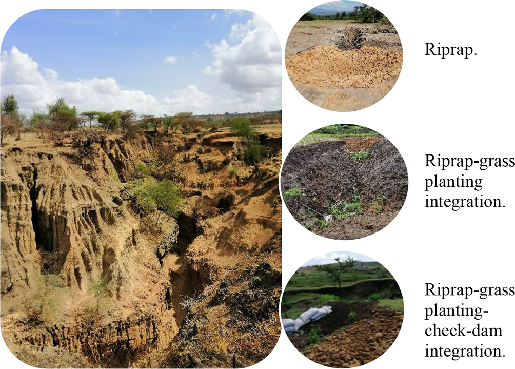
Severe gully erosion resulting from deforestation and poor land management practices.
Process: Sheet erosion → Rill erosion → Gully erosion progression
Causes: Deforestation, overgrazing, steep slopes, intense seasonal rainfall
Impact: Loss of fertile topsoil, reduced agricultural productivity, land degradation
Example 3: Afar Region Sand Dunes

Characteristic crescent-shaped barchan dunes formed by consistent wind direction in the Afar Depression.
Process: Wind erosion (deflation) and deposition
Feature: Barchan dunes with horns pointing downwind
Conditions: Arid climate, limited vegetation, consistent wind direction, limited sand supply
Example 4: Landslide Risk Areas

Mass wasting event triggered by heavy rainfall on deforested, steep slopes.
Process: Mass wasting (rapid downslope movement)
Triggers: Heavy rainfall, steep slopes, removal of vegetation, weak or fractured rock
Impact: Destruction of roads, buildings, agricultural land; potential loss of life
Prevention: Maintain vegetation cover, proper drainage, avoid construction on unstable slopes
Example 5: Delta Formation

Satellite view of a river delta showing the characteristic fan shape formed by sediment deposition.
Process: Deposition at river mouth (lower course)
Formation: River slows when entering larger water body → Loses energy → Deposits sediment load
Characteristics: Extremely fertile soil, dense population, important for agriculture
Famous Example: Nile Delta (Egypt)—one of the world’s most fertile agricultural regions
Activity 1: Multiple Choice Questions
Test your knowledge of external forces with these multiple-choice questions. Select one answer for each question.
Question 1: What is the primary source of energy for exogenic forces?
Question 2: Which type of weathering involves the breakdown of rocks without changing their chemical composition?
Question 3: What landform is created when a river meander is cut off from the main channel?
Question 4: Which of the following is a crescent-shaped sand dune formed in desert areas?
Question 5: The progression from sheet erosion to gully erosion indicates:
Activity 2: True or False
Determine whether each statement is true or false.
Statement 1: Exogenic forces are land-building forces that create mountains and plateaus.
Statement 2: Chemical weathering is most effective in warm, humid climates.
Statement 3: Mass wasting requires a transporting medium like water or wind to move materials downslope.
Statement 4: Deltas form at the mouth of rivers where deposition exceeds erosion.
Statement 5: Deforestation and overgrazing increase the risk of soil erosion and mass wasting.
Activity 3: Mixed Challenge
This activity contains a mix of question types to challenge your understanding.
Question 1: Match the weathering type with its correct example.
Select the correct weathering type for: “Water freezes in rock cracks, expands, and breaks the rock apart”
Question 2: Fill in the Blank
The three main external processes that reshape Earth’s surface are weathering, erosion, and .
Question 3: What is the correct sequence of river course sections from source to mouth?
Question 4: Which factor MOST increases the risk of landslides in Ethiopian highlands?
Question 5: A farmer notices that soil is being washed away in small channels during rainy season. What type of erosion is occurring?
Lesson Summary
Exogenic forces are external geological processes powered by the Sun and gravity that continuously wear down and reshape Earth’s surface features.
Weathering breaks down rocks in place through physical (mechanical), chemical, or biological processes, preparing material for erosion.
Mass wasting is the downslope movement of material under gravity’s direct influence, with water, slope angle, and vegetation as controlling factors.
Running water is the most powerful erosive agent, creating features from V-shaped valleys and waterfalls in upper courses to meanders and deltas in lower courses.
Wind erosion is most effective in arid regions, forming sand dunes (including barchan dunes) and depositing fertile loess in other areas.
Coastal processes involve both erosion and deposition, creating features like beaches, spits, lagoons, and cliffs.
External forces interact—weathering prepares material, erosion transports it, and deposition creates new landforms. Climate determines which processes dominate.
Environmental management is crucial to prevent soil erosion, landslides, and desertification, especially in areas with deforestation and poor land practices.
Key Takeaway: External forces are continuously sculpting Earth’s surface—understanding them helps us predict landscape changes and manage environmental risks!
Assessment
Test your overall understanding of External (Exogenic) Forces with this comprehensive assessment.